Index of /assets/93fdd853fedc9b94434a688073830098/image/png/438x280
Name
Last modified
Size
Description
Parent Directory
-
Buffer_Tool.png
2021-03-12 12:00
36K
CAlWaterPlan_2018Update.png
2020-03-10 17:27
218K
CT_Turbidity_-_WFST_Winter_2016-2017.png
2020-12-11 12:59
189K
CT_Turbidty_test_12-18-1.png
2020-03-10 17:27
286K
CVP_-_SWP_Pumping_and_Vernalis_Flows.png
2020-06-05 12:27
210K
Calculate_Acreage.png
2021-03-12 12:00
54K
California_Tiger_Salamander_Range.png
2020-03-10 17:27
180K
Delta_Agricultural_Lands.png
2020-03-10 17:27
225K
Delta_Crop_Map.png
2020-03-10 17:27
240K
EDSM_Weekly_Testing.png
2020-10-09 10:13
231K
EcoRestore1.png
2020-03-10 17:27
80K
EcoRestore2.png
2020-03-10 17:27
102K
EcoRestore3.png
2020-03-10 17:27
115K
Giant_Gartersnake_Range.png
2020-03-10 17:27
189K
IEP_cover.png
2020-03-10 17:27
53K
IEP_thumb.png
2020-03-10 17:27
84K
Least_Bell's_Vireo_Range.png
2020-03-10 17:27
181K
Least_Bell's_Vireo_eBird_Historic_Observations.png
2020-03-10 17:27
190K
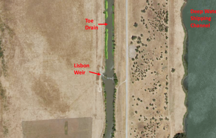
LisbonWeirNAIP_marked.png
2020-03-10 17:27
216K
MISC_tools.png
2020-07-22 11:48
295K
Monthly_Reservoir_Percent_Capacity.png
2020-03-10 17:27
175K
My_CT_Test_-_7_days.png
2020-03-10 17:27
210K
My_CT_Testing.png
2020-03-10 17:27
213K
My_USGS_Test.png
2020-08-11 09:34
188K
NEXRAD_Map__Mapquest_OSM.png
2020-05-14 12:53
180K
North_Sierra_8_Station_Index;_Season_to_Date_Precip_Accumulated.png
2020-03-10 17:27
194K
North_Sierra_8_Station_Precip_Index_Daily_Precipitation_Incremental.png
2020-03-10 17:27
201K
PBBB_USFWS.png
2020-03-10 17:27
240K
PBBB_usfws2.png
2020-03-10 17:27
234K
Palmate-bracted_Bird's_Beak_Range.png
2020-03-10 17:27
187K
Remove_a_Feature.png
2021-03-12 12:00
37K
Reservoir_Tool_Map.png
2021-06-15 09:54
176K
River_Flows_and_Pumping.png
2021-03-02 13:04
162K
San_Joaquin_5-Station_Index_Daily_Precipitation_Incremental.png
2020-03-10 17:27
200K
San_Joaquin_5_Station_Index_Season_to_Date_Precip_Accumulated.png
2020-03-10 17:27
232K
Screen_Shot_2019-08-05_at_11.43.30_AM.png
2020-03-10 17:27
50K
Screen_Shot_2019-08-05_at_11.46.58_AM.png
2020-03-10 17:27
55K
Screen_Shot_2019-08-05_at_12.11.34_PM.png
2020-03-10 17:27
172K
Screen_Shot_2019-09-19_at_9.15.30_AM.png
2020-03-10 17:27
31K
Screen_Shot_2019-10-28_at_5.00.29_PM.png
2020-03-10 17:27
219K
Select_Features_Tool.png
2021-03-12 12:00
48K
Swainson's_Hawk_eBird_Historic_Observations.png
2020-03-10 17:27
196K
Timeline_Testing.png
2020-03-10 17:27
170K
Tricolored_Blackbird_eBird_Historic_Observations.png
2020-03-10 17:27
190K
Tulare_Basin_6_Station_Index_Season_to_Date_Precip._Accumulated.png
2020-03-10 17:27
189K
Tulare_Basin_6_Station_Precip_Index_Daily_Precip._Incremental.png
2020-03-10 17:27
191K
Valley_Elderberry_Longhorn_Beetle_Range.png
2020-03-10 17:27
191K
WBYA.png
2020-03-10 17:27
158K
WaterSupply_05042020.png
2020-05-06 09:37
117K
WaterSupply_08202019.png
2020-03-10 17:27
120K
WaterSupply_11032019.png
2020-03-10 17:27
118K
WaterSupply_11202019.png
2020-03-10 17:27
118K
WaterSupply_20190722.png
2020-03-10 17:27
115K
WaterSupply_20190930.png
2020-03-10 17:27
117K
WaterSupply_20191209.png
2020-03-10 17:27
119K
Waterr_Supply_09262019.png
2020-03-10 17:27
117K
Western_Burrowing_Owl.png
2020-03-10 17:27
187K
Western_Yellow-billed_Cuckoo_eBird_Historic_Observations.png
2020-03-10 17:27
188K
White-tailed_Kite_eBird_Historic_Observations.png
2020-03-10 17:27
186K
YBWA_map_img.png
2020-03-10 17:27
162K
Yolo_Basin_Chlorophyll_(CDEC_last_7_days)_.png
2020-03-10 17:27
227K
Yolo_Basin_Critical_Wildlife_Habitat.png
2020-03-10 17:27
1.1K
Yolo_Basin_River_Forecasts_(NOAA_Last_7_Days).png
2020-03-10 17:27
226K
Yolo_Basin_Tidal_Predictions_(NOAA_last_7_days).png
2020-03-10 17:27
228K
Yolo_Basin_Turbidity_(CDEC_last_7_days).png
2020-03-10 17:27
228K
Yolo_Basin_Water_Temperature_(CDEC_last_7_days).png
2020-03-10 17:27
228K
Yolo_Basin_Weirs.png
2020-03-10 17:27
226K
Yolo_CritHab_Map.png
2020-03-10 17:27
231K
butte_cs_small.png
2021-03-01 13:48
46K
getAllLayerTimes_Test.png
2020-03-10 17:27
230K
retro_timeline_testing.png
2020-03-10 17:27
186K
test.png
2020-03-10 17:27
226K
watersupply_010620.png
2020-03-10 17:27
113K
watersupply_01262020.png
2020-03-10 17:27
117K
watersupply_12082019.png
2020-03-10 17:27
118K
watersupply_12222019.png
2020-03-10 17:27
116K
watersupply_12292019.png
2020-03-10 17:27
116K
Apache/2.4.52 (Ubuntu) Server at emp.baydeltalive.com Port 443
_.png)
.png)
.png)
.png)
.png)