Index of /assets/93fdd853fedc9b94434a688073830098/image/png/640x480
Name
Last modified
Size
Description
Parent Directory
-
Buffer_Tool.png
2021-03-12 12:00
48K
CAlWaterPlan_2018Update.png
2020-03-10 17:27
478K
CT_Turbidity_-_WFST_Winter_2016-2017.png
2020-12-11 12:59
426K
CT_Turbidty_test_12-18-1.png
2020-03-10 17:27
688K
CVP_-_SWP_Pumping_and_Vernalis_Flows.png
2020-06-05 12:27
473K
Calculate_Acreage.png
2021-03-12 12:00
63K
California_Tiger_Salamander_Range.png
2020-03-10 17:27
451K
Delta_Agricultural_Lands.png
2020-03-10 17:27
533K
Delta_Crop_Map.png
2020-03-10 17:27
578K
EDSM_Weekly_Testing.png
2020-10-09 10:13
563K
EcoRestore1.png
2020-03-10 17:27
150K
EcoRestore2.png
2020-03-10 17:27
256K
EcoRestore3.png
2020-03-10 17:27
142K
Giant_Gartersnake_Range.png
2020-03-10 17:27
473K
IEP_cover.png
2020-03-10 17:27
124K
IEP_thumb.png
2020-03-10 17:27
178K
Least_Bell's_Vireo_Range.png
2020-03-10 17:27
452K
Least_Bell's_Vireo_eBird_Historic_Observations.png
2020-03-10 17:27
462K
LisbonWeirNAIP_marked.png
2020-03-10 17:27
476K
MISC_tools.png
2020-07-22 11:48
684K
Monthly_Reservoir_Percent_Capacity.png
2020-03-10 17:27
396K
My_CT_Test_-_7_days.png
2020-03-10 17:27
461K
My_CT_Testing.png
2020-03-10 17:27
484K
My_USGS_Test.png
2020-08-11 09:34
429K
NEXRAD_Map__Mapquest_OSM.png
2020-05-14 12:53
419K
North_Sierra_8_Station_Index;_Season_to_Date_Precip_Accumulated.png
2020-03-10 17:27
487K
North_Sierra_8_Station_Precip_Index_Daily_Precipitation_Incremental.png
2020-03-10 17:27
504K
PBBB_USFWS.png
2020-03-10 17:27
330K
PBBB_usfws2.png
2020-03-10 17:27
344K
Palmate-bracted_Bird's_Beak_Range.png
2020-03-10 17:27
468K
Remove_a_Feature.png
2021-03-12 12:00
49K
Reservoir_Tool_Map.png
2021-06-15 09:54
405K
River_Flows_and_Pumping.png
2021-03-02 13:04
377K
San_Joaquin_5-Station_Index_Daily_Precipitation_Incremental.png
2020-03-10 17:27
495K
San_Joaquin_5_Station_Index_Season_to_Date_Precip_Accumulated.png
2020-03-10 17:27
574K
Screen_Shot_2019-08-05_at_11.43.30_AM.png
2020-03-10 17:27
150K
Screen_Shot_2019-08-05_at_11.46.58_AM.png
2020-03-10 17:27
160K
Screen_Shot_2019-08-05_at_12.11.34_PM.png
2020-03-10 17:27
377K
Screen_Shot_2019-09-19_at_9.15.30_AM.png
2020-03-10 17:27
24K
Screen_Shot_2019-10-28_at_5.00.29_PM.png
2020-03-10 17:27
492K
Select_Features_Tool.png
2021-03-12 12:00
57K
Swainson's_Hawk_eBird_Historic_Observations.png
2020-03-10 17:27
473K
Timeline_Testing.png
2020-03-10 17:27
415K
Tricolored_Blackbird_eBird_Historic_Observations.png
2020-03-10 17:27
451K
Tulare_Basin_6_Station_Index_Season_to_Date_Precip._Accumulated.png
2020-03-10 17:27
470K
Tulare_Basin_6_Station_Precip_Index_Daily_Precip._Incremental.png
2020-03-10 17:27
474K
Valley_Elderberry_Longhorn_Beetle_Range.png
2020-03-10 17:27
480K
WBYA.png
2020-03-10 17:27
365K
WaterSupply_05042020.png
2020-05-06 09:37
226K
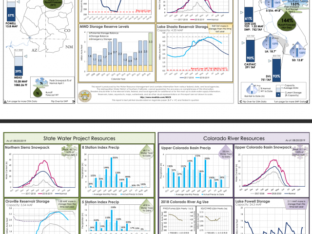
WaterSupply_08202019.png
2020-03-10 17:27
278K
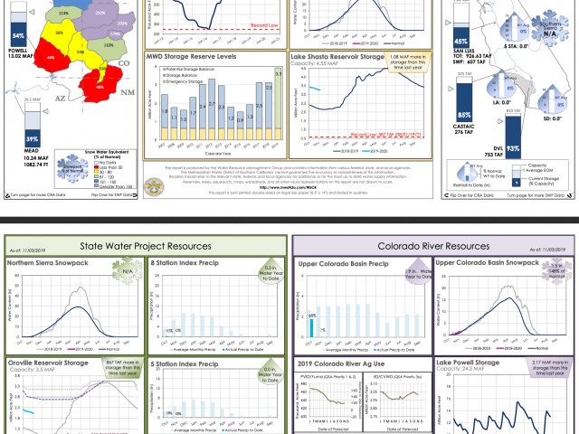
WaterSupply_11032019.png
2020-03-10 17:27
270K
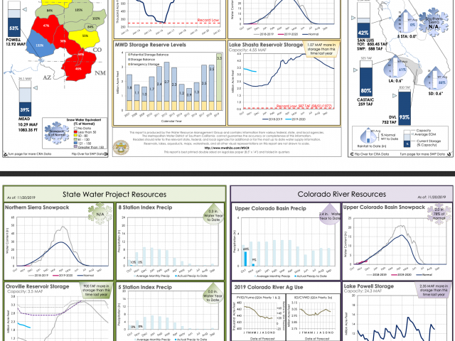
WaterSupply_11202019.png
2020-03-10 17:27
279K
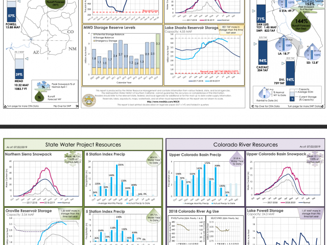
WaterSupply_20190722.png
2020-03-10 17:27
281K
WaterSupply_20190930.png
2020-03-10 17:27
275K
WaterSupply_20191209.png
2020-03-10 17:27
280K
Waterr_Supply_09262019.png
2020-03-10 17:27
276K
Western_Burrowing_Owl.png
2020-03-10 17:27
456K
Western_Yellow-billed_Cuckoo_eBird_Historic_Observations.png
2020-03-10 17:27
457K
White-tailed_Kite_eBird_Historic_Observations.png
2020-03-10 17:27
442K
YBWA_map_img.png
2020-03-10 17:27
384K
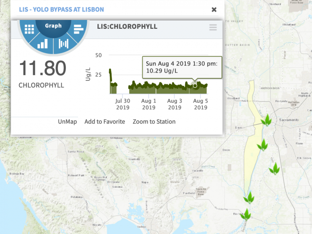
Yolo_Basin_Chlorophyll_(CDEC_last_7_days)_.png
2020-03-10 17:27
533K
Yolo_Basin_Critical_Wildlife_Habitat.png
2020-03-10 17:27
2.3K
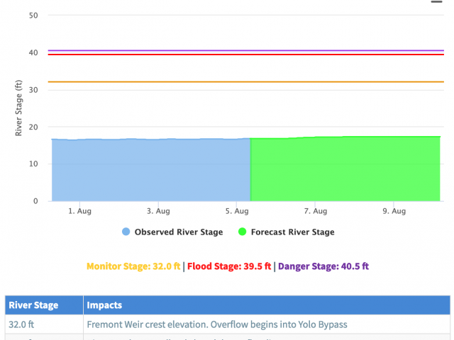
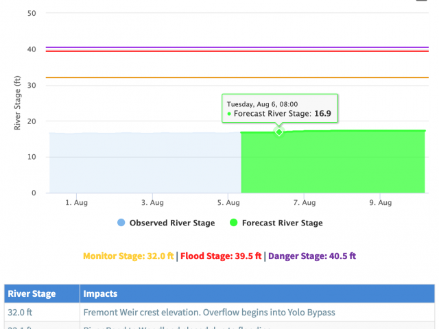
Yolo_Basin_River_Forecasts_(NOAA_Last_7_Days).png
2020-03-10 17:27
532K
Yolo_Basin_Tidal_Predictions_(NOAA_last_7_days).png
2020-03-10 17:27
532K
Yolo_Basin_Turbidity_(CDEC_last_7_days).png
2020-03-10 17:27
533K
Yolo_Basin_Water_Temperature_(CDEC_last_7_days).png
2020-03-10 17:27
532K
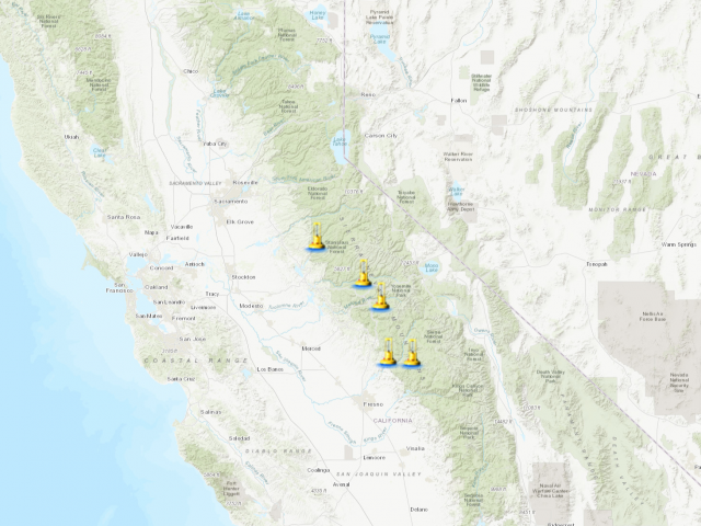
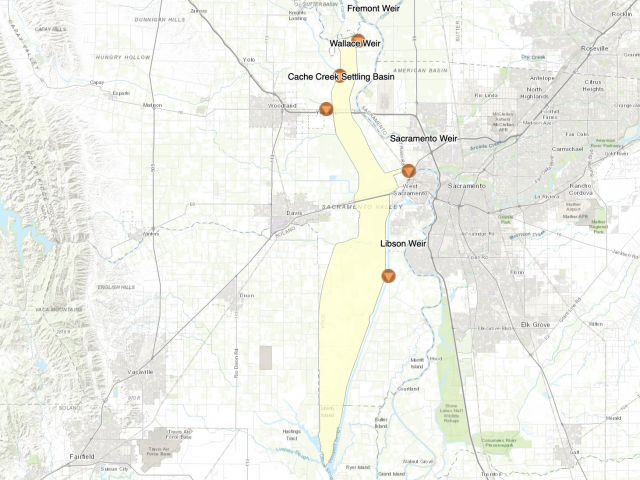
Yolo_Basin_Weirs.png
2020-03-10 17:27
530K
Yolo_CritHab_Map.png
2020-03-10 17:27
533K
butte_cs_small.png
2021-03-01 13:48
134K
getAllLayerTimes_Test.png
2020-03-10 17:27
574K
retro_timeline_testing.png
2020-03-10 17:27
460K
test.png
2020-03-10 17:27
565K
watersupply_010620.png
2020-03-10 17:27
239K
watersupply_01262020.png
2020-03-10 17:27
279K
watersupply_12082019.png
2020-03-10 17:27
283K
watersupply_12222019.png
2020-03-10 17:27
277K
watersupply_12292019.png
2020-03-10 17:27
278K
Apache/2.4.52 (Ubuntu) Server at emp.baydeltalive.com Port 443
_.png)
.png)
.png)
.png)
.png)