![[ICO]](/icons/blank.gif) | Name | Last modified | Size | Description |
|---|
|
|---|
![[PARENTDIR]](/icons/back.gif) | Parent Directory | | - | |
![[DIR]](/icons/folder.gif) | 70x70/ | 2021-06-14 11:26 | - | |
| 135x104/ | 2021-06-14 11:26 | - | |
| 145x120/ | 2021-06-14 11:26 | - | |
| 320x240/ | 2021-06-14 11:25 | - | |
| 438x280/ | 2021-06-14 11:25 | - | |
| 640x480/ | 2021-06-14 11:25 | - | |
![[IMG]](/icons/image2.gif) | Buffer_Tool.png | 2021-03-12 12:00 | 4.7K | |
| CAlWaterPlan_2018Update.png | 2020-03-10 17:27 | 2.9M | |
| CT_Turbidity_-_WFST_Winter_2016-2017.png | 2020-12-11 12:59 | 1.1M | |
| CT_Turbidty_test_12-18-1.png | 2020-03-10 17:27 | 12M | |
| CVP_-_SWP_Pumping_and_Vernalis_Flows.png | 2020-06-05 12:27 | 8.0M | |
| Calculate_Acreage.png | 2021-03-12 12:00 | 8.4K | |
| California_Tiger_Salamander_Range.png | 2020-03-10 17:27 | 2.3M | |
| Delta_Agricultural_Lands.png | 2020-03-10 17:27 | 3.5M | |
| Delta_Crop_Map.png | 2020-03-10 17:27 | 3.7M | |
| EDSM_Weekly_Testing.png | 2020-10-09 10:13 | 5.3M | |
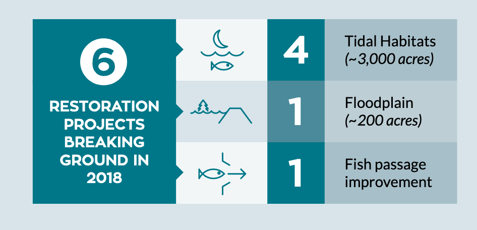
| EcoRestore1.png | 2020-03-10 17:27 | 48K | |
| EcoRestore2.png | 2020-03-10 17:27 | 50K | |
| EcoRestore3.png | 2020-03-10 17:27 | 74K | |
| Giant_Gartersnake_Range.png | 2020-03-10 17:27 | 2.5M | |
| IEP_cover.png | 2020-03-10 17:27 | 201K | |
| IEP_thumb.png | 2020-03-10 17:27 | 141K | |
| Least_Bell's_Vireo_Range.png | 2020-03-10 17:27 | 2.3M | |
| Least_Bell's_Vireo_eBird_Historic_Observations.png | 2020-03-10 17:27 | 2.3M | |
| LisbonWeirNAIP_marked.png | 2020-03-10 17:27 | 2.8M | |
| MISC_tools.png | 2020-07-22 11:48 | 8.9M | |
| Monthly_Reservoir_Percent_Capacity.png | 2020-03-10 17:27 | 3.8M | |
| My_CT_Test_-_7_days.png | 2020-03-10 17:27 | 8.0M | |
| My_CT_Testing.png | 2020-03-10 17:27 | 6.2M | |
| My_USGS_Test.png | 2020-08-11 09:34 | 3.7M | |
| NEXRAD_Map__Mapquest_OSM.png | 2020-05-14 12:53 | 4.9M | |
| North_Sierra_8_Station_Index;_Season_to_Date_Precip_Accumulated.png | 2020-03-10 17:27 | 2.7M | |
| North_Sierra_8_Station_Precip_Index_Daily_Precipitation_Incremental.png | 2020-03-10 17:27 | 2.9M | |
| PBBB_USFWS.png | 2020-03-10 17:27 | 225K | |
| PBBB_usfws2.png | 2020-03-10 17:27 | 225K | |
| Palmate-bracted_Bird's_Beak_Range.png | 2020-03-10 17:27 | 2.4M | |
| Remove_a_Feature.png | 2021-03-12 12:00 | 6.9K | |
| Reservoir_Tool_Map.png | 2021-06-15 09:54 | 6.1M | |
| River_Flows_and_Pumping.png | 2021-03-02 13:04 | 912K | |
| San_Joaquin_5-Station_Index_Daily_Precipitation_Incremental.png | 2020-03-10 17:27 | 2.9M | |
| San_Joaquin_5_Station_Index_Season_to_Date_Precip_Accumulated.png | 2020-03-10 17:27 | 4.1M | |
| Screen_Shot_2019-08-05_at_11.43.30_AM.png | 2020-03-10 17:27 | 152K | |
| Screen_Shot_2019-08-05_at_11.46.58_AM.png | 2020-03-10 17:27 | 161K | |
| Screen_Shot_2019-08-05_at_12.11.34_PM.png | 2020-03-10 17:27 | 1.6M | |
| Screen_Shot_2019-09-19_at_9.15.30_AM.png | 2020-03-10 17:27 | 14K | |
| Screen_Shot_2019-10-28_at_5.00.29_PM.png | 2020-03-10 17:27 | 3.2M | |
| Select_Features_Tool.png | 2021-03-12 12:00 | 6.7K | |
| Swainson's_Hawk_eBird_Historic_Observations.png | 2020-03-10 17:27 | 2.2M | |
| Timeline_Testing.png | 2020-03-10 17:27 | 2.5M | |
| Tricolored_Blackbird_eBird_Historic_Observations.png | 2020-03-10 17:27 | 2.1M | |
| Tulare_Basin_6_Station_Index_Season_to_Date_Precip._Accumulated.png | 2020-03-10 17:27 | 2.5M | |
| Tulare_Basin_6_Station_Precip_Index_Daily_Precip._Incremental.png | 2020-03-10 17:27 | 2.6M | |
| Valley_Elderberry_Longhorn_Beetle_Range.png | 2020-03-10 17:27 | 2.6M | |
| WBYA.png | 2020-03-10 17:27 | 893K | |
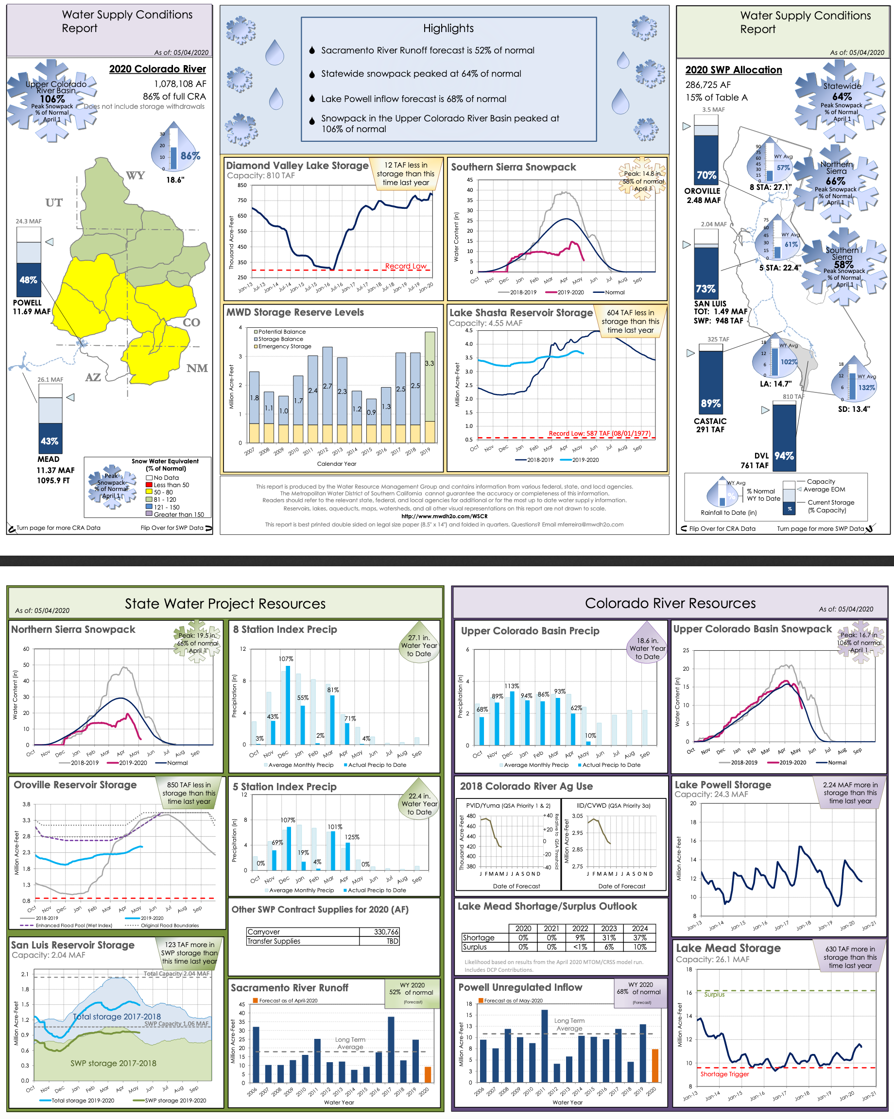
| WaterSupply_05042020.png | 2020-05-06 09:37 | 1.4M | |
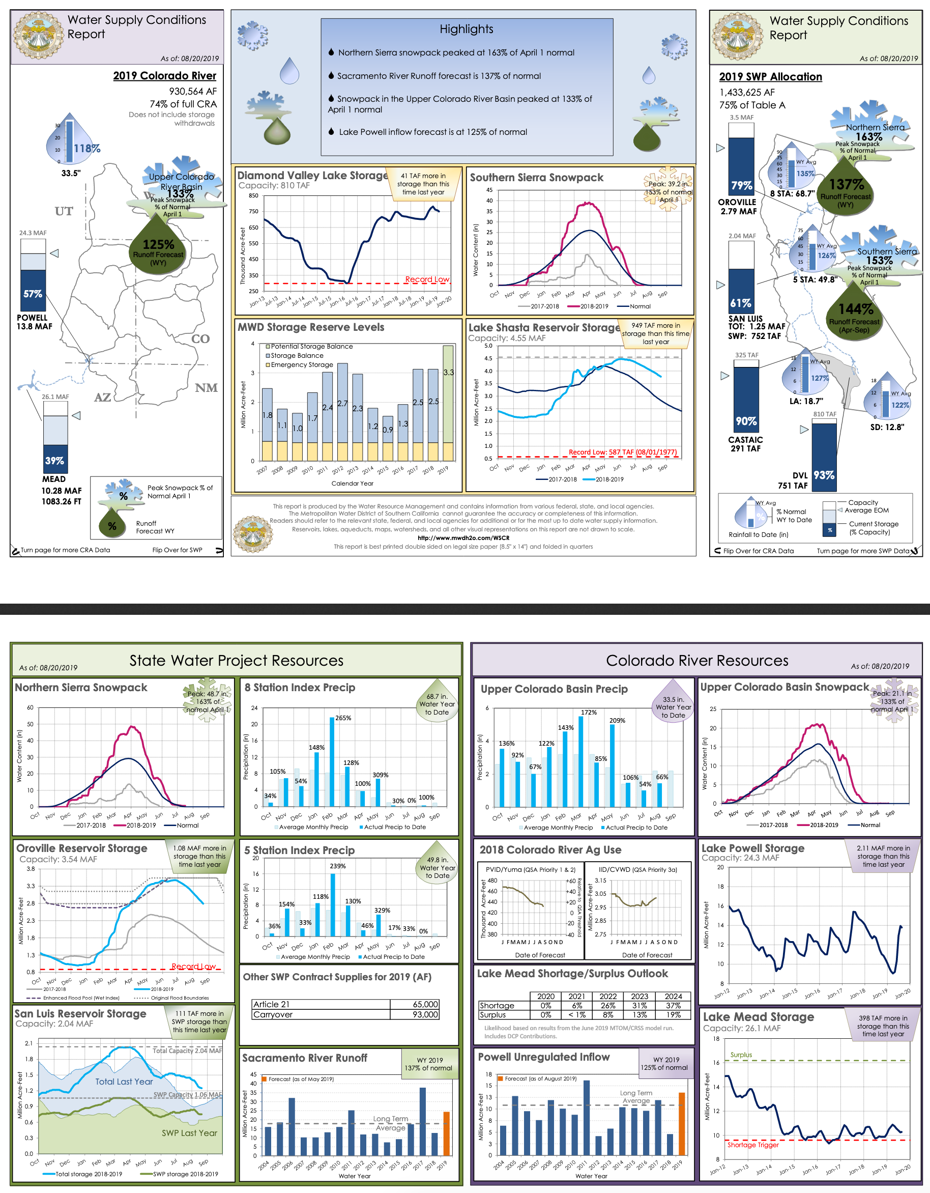
| WaterSupply_08202019.png | 2020-03-10 17:27 | 1.5M | |
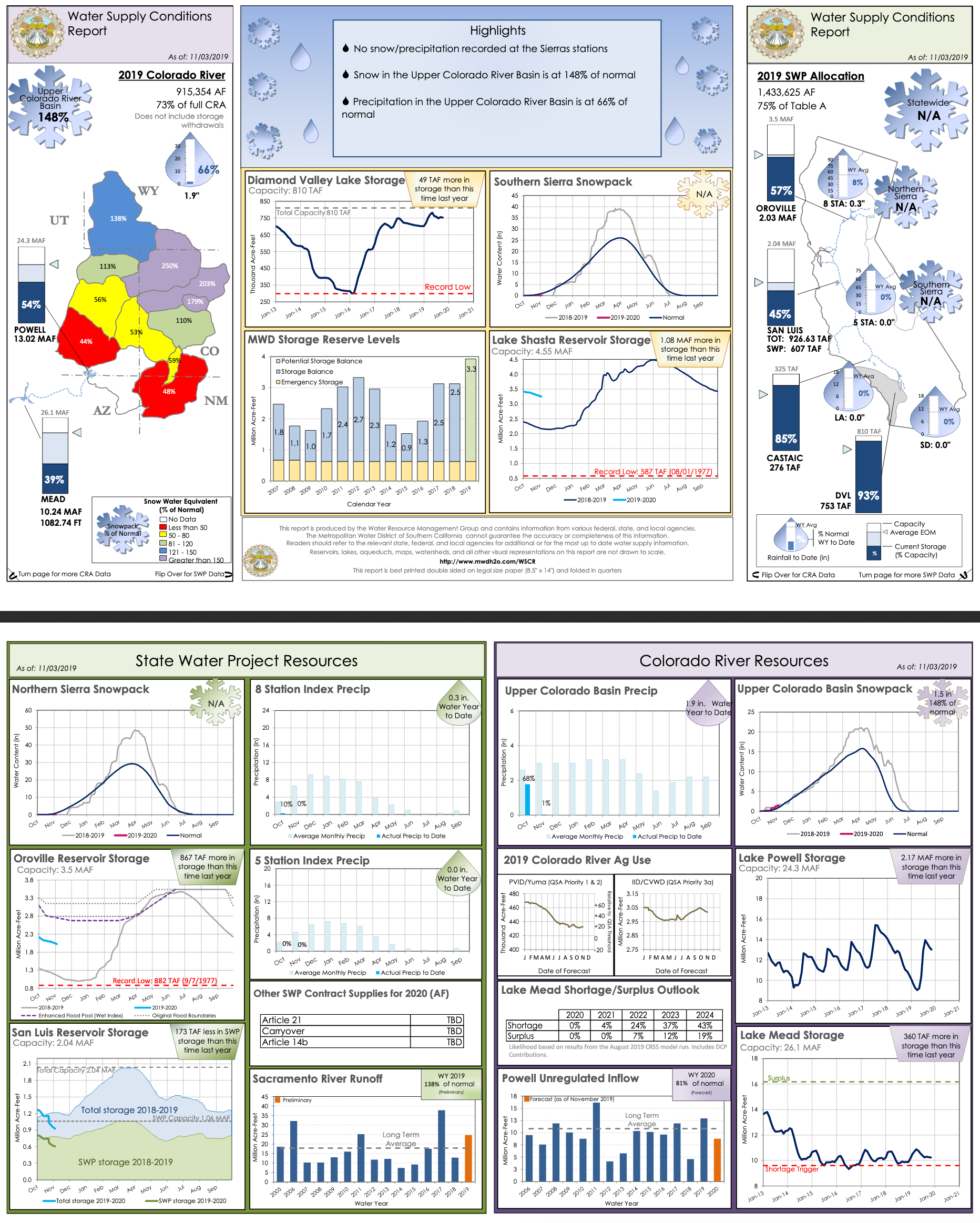
| WaterSupply_11032019.png | 2020-03-10 17:27 | 1.5M | |
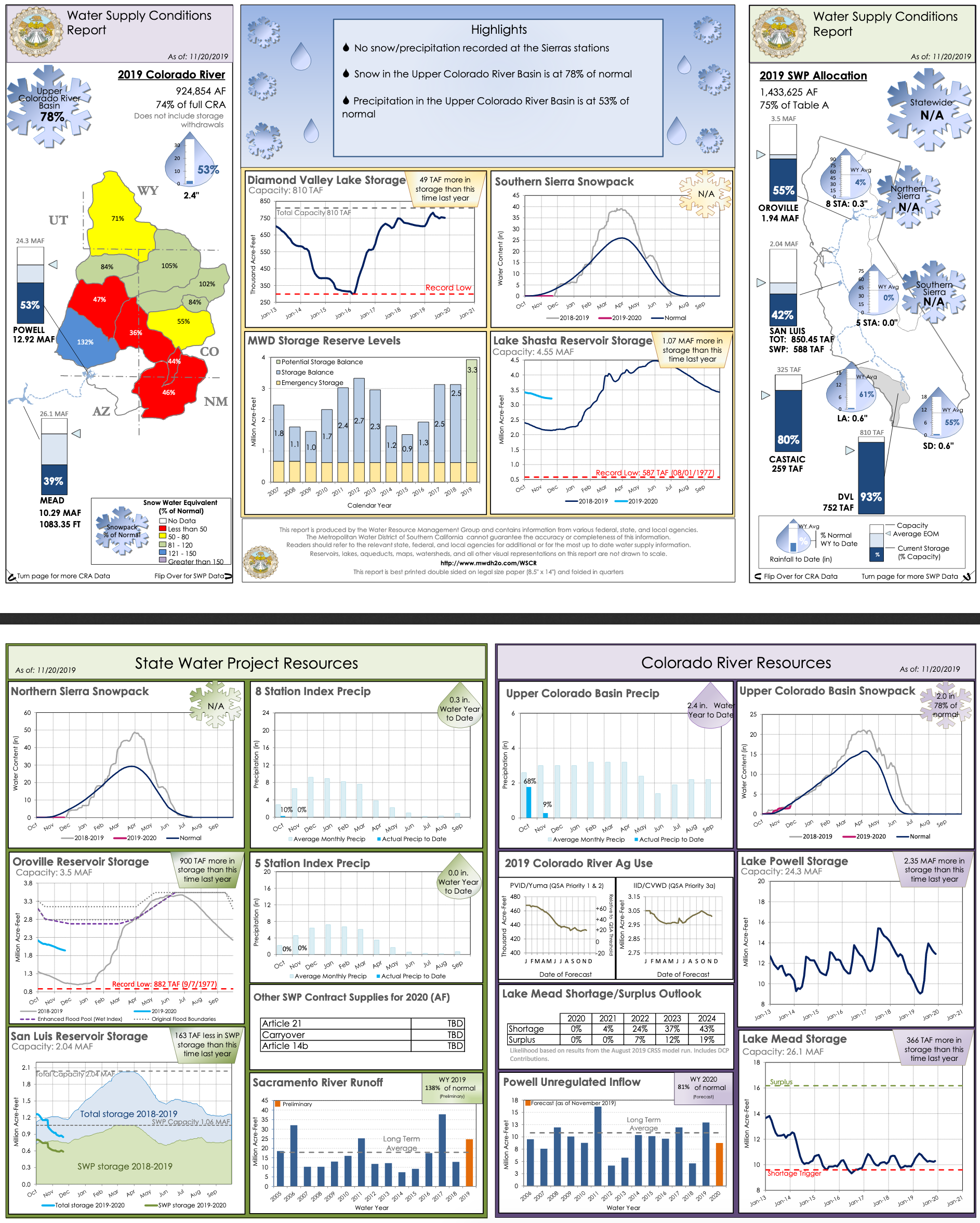
| WaterSupply_11202019.png | 2020-03-10 17:27 | 1.6M | |
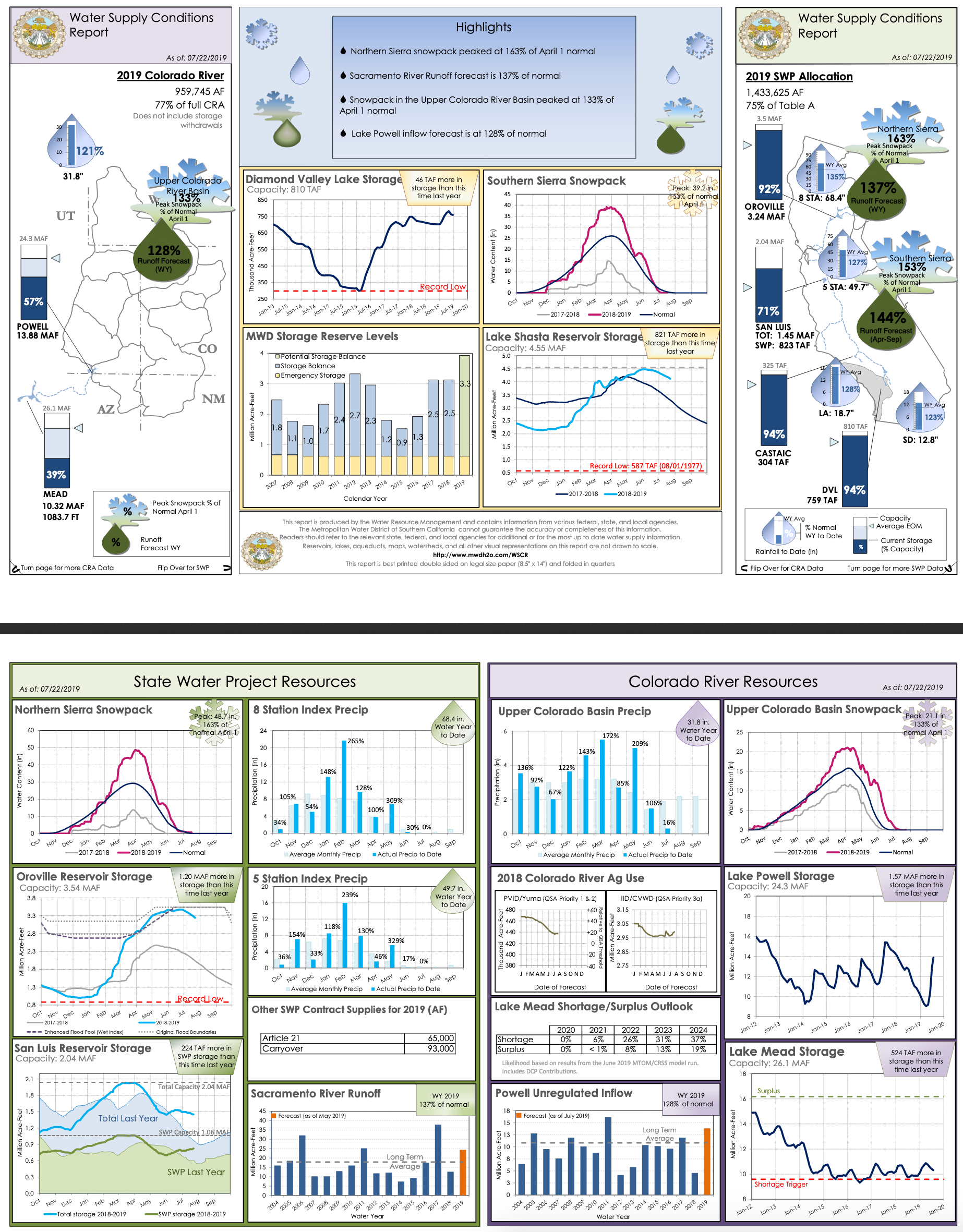
| WaterSupply_20190722.png | 2020-03-10 17:27 | 1.5M | |
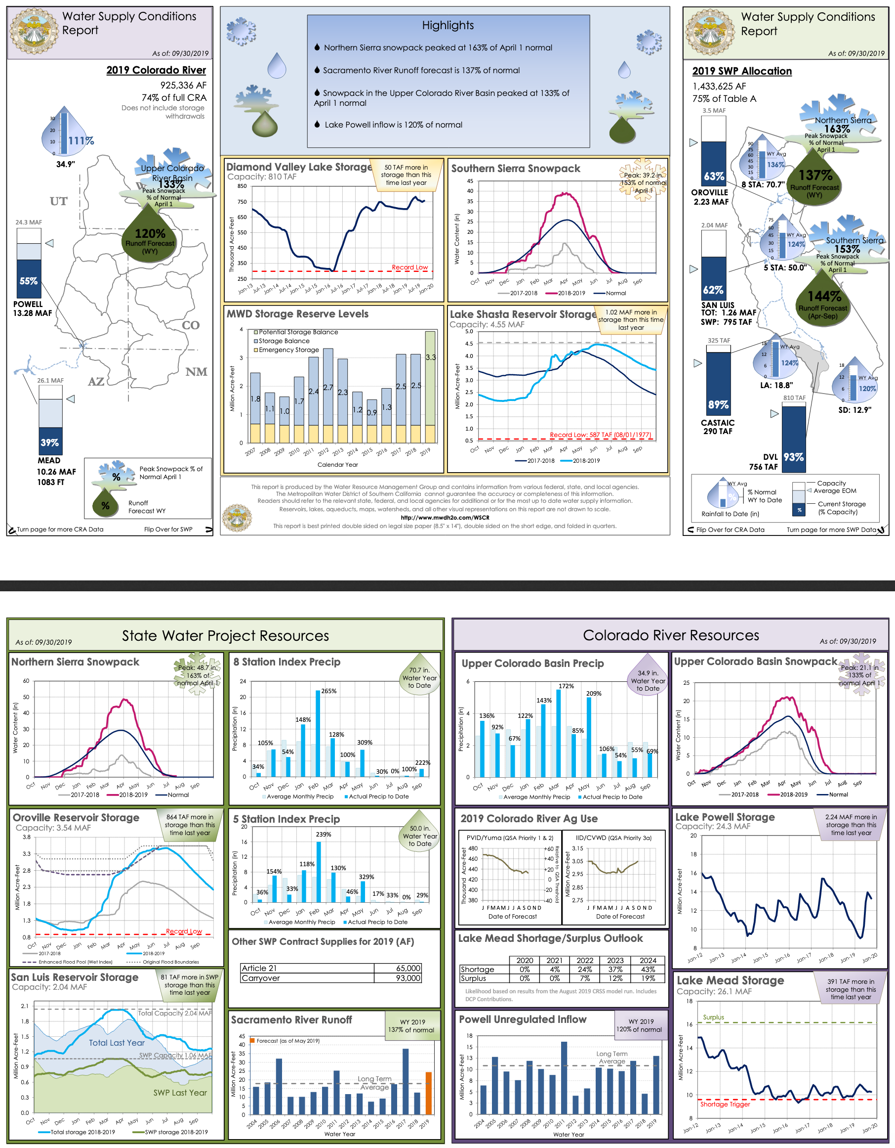
| WaterSupply_20190930.png | 2020-03-10 17:27 | 1.5M | |
| WaterSupply_20191209.png | 2020-03-10 17:27 | 1.5M | |
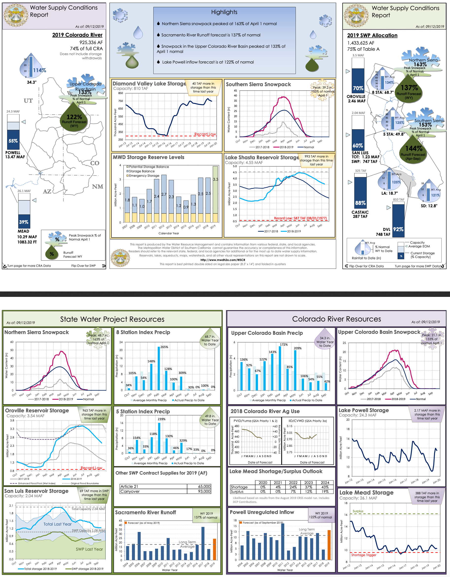
| Waterr_Supply_09262019.png | 2020-03-10 17:27 | 1.5M | |
| Western_Burrowing_Owl.png | 2020-03-10 17:27 | 2.3M | |
| Western_Yellow-billed_Cuckoo_eBird_Historic_Observations.png | 2020-03-10 17:27 | 2.3M | |
| White-tailed_Kite_eBird_Historic_Observations.png | 2020-03-10 17:27 | 2.0M | |
| YBWA_map_img.png | 2020-03-10 17:27 | 1.7M | |
| Yolo_Basin_Chlorophyll_(CDEC_last_7_days)_.png | 2020-03-10 17:27 | 4.2M | |
| Yolo_Basin_River_Forecasts_(NOAA_Last_7_Days).png | 2020-03-10 17:27 | 4.1M | |
| Yolo_Basin_Tidal_Predictions_(NOAA_last_7_days).png | 2020-03-10 17:27 | 4.2M | |
| Yolo_Basin_Turbidity_(CDEC_last_7_days).png | 2020-03-10 17:27 | 4.2M | |
| Yolo_Basin_Water_Temperature_(CDEC_last_7_days).png | 2020-03-10 17:27 | 4.2M | |
| Yolo_Basin_Weirs.png | 2020-03-10 17:27 | 3.8M | |
| Yolo_CritHab_Map.png | 2020-03-10 17:27 | 3.0M | |
| butte_cs_small.png | 2021-03-01 13:48 | 10K | |
| getAllLayerTimes_Test.png | 2020-03-10 17:27 | 4.5M | |
| retro_timeline_testing.png | 2020-03-10 17:27 | 6.9M | |
| test.png | 2020-03-10 17:27 | 4.4M | |
| watersupply_010620.png | 2020-03-10 17:27 | 1.5M | |
| watersupply_01262020.png | 2020-03-10 17:27 | 1.5M | |
| watersupply_12082019.png | 2020-03-10 17:27 | 1.5M | |
| watersupply_12222019.png | 2020-03-10 17:27 | 1.5M | |
| watersupply_12292019.png | 2020-03-10 17:27 | 1.6M | |
|
|---|
_.png)
.png)
.png)
.png)
.png)