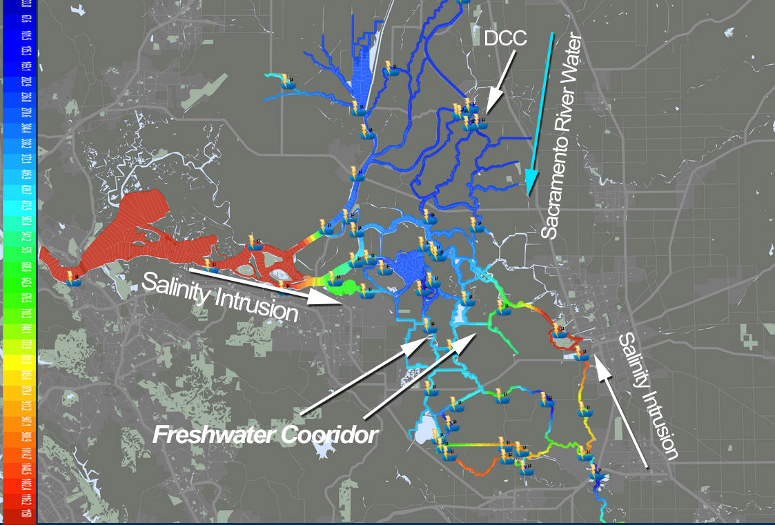
Caption:Salinity Intrusion and the Fresh Water Cooridor Illustrated
Flows and water quality in the Sacramento-San Joaquin Delta (Delta) are strongly influenced by freshwater inflow from the rivers, by the tides in San Francisco Bay and by salinity from Bay waters. Prior to human influence, the historical distribution of salinity in the Delta was controlled primarily by the seasonal and inter-annual distribution of precipitation, the geomorphology of the Bay and Delta, daily tides, the spring-neap tidal cycle, and the mean sea level at Golden Gate. Extended wet and dry periods are both evident in the historical record. Since about 1860, a number of morphological changes to the Delta landscape and operational changes of reservoirs and water diversions have affected flows and the distribution of salinity within the Delta.
Salinity controls exports during droughts. As river flows entering the delta decrease, the water in the south delta will become so salty it will be unusable and exports from the delta will stop. This document outlines a number of alternatives for “controlling” the salt field in the central delta. These alternatives principally rely on strategically placed “temporary” barriers. In the absence of these barriers, a great deal of water will be used to repel salinity intrusion in the delta, rather than being kept in reservoirs for future use or exported.
Caption:Salinity Intrusion and the Fresh Water Cooridor Illustrated
There number of drought mitigation strategies that will allow the water projects to reduce reservoir releases, minimize the impacts on the ecosystem of very low river flows and continue to deliver water to the greatest extent possible as water supplies dwindle. A variety of numerical models are being used to evaluate the response of the salt field to a sequence of mitigation measures, which involve export curtailments, reservoir releases, gate operations and temporary barriers. All of these strategies could help us minimize the amount of water needed to keep the “fresh water corridor” as fresh and as dilated as possible.
Possible solutions to decrease the amount of Sacramento River needed to repel salinity intrusion in the central delta.
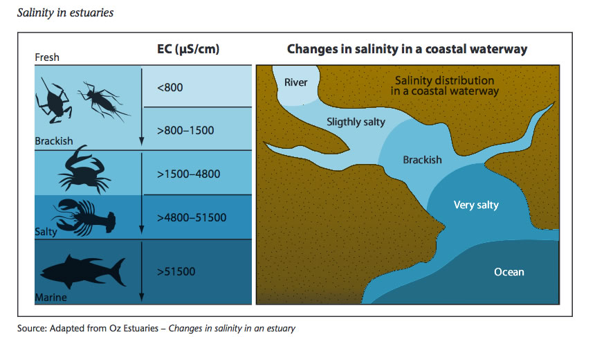
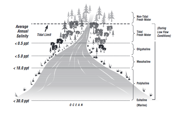
Salinity is simply a measure of the amount of salts dissolved in water. Salinity is usually expressed in parts per thousand (ppt) or 0/00. Fresh water in rivers has a salinity of 0.5 ppt or less. Within an estuary, salinity levels are referred to as oligohaline (0.5-5.0 ppt), mesohaline (5.0-18.0 ppt), or polyhaline (18.0¬-30.0ppt). Near the connection with the open sea, estuarine waters may be euhaline, where salinity levels are the same as the ocean at more than 30.0 ppt (Mitsch and Gosselink, 1986)
|
Sources of salt are categorized by [ACTIVITY] |
Sources of salt are categorized by [ORIGIN] |
|
Tidal |
|
|
Agriculture |
Evapoconcentrated from supply water |
|
Municipal |
Added through dissolution of naturally occurring salts |
|
Industrial |
Through explicit addition of salts, e.g. fertilizers or in food processing |
|
Natural Discharges |
Through importation of water supply |
|
** or combination of sources listed above |
The data dashboard below provides you with daily data for salinity and other related conditions in the Sacramento San Joaquin Delta. Data is displayed as visualizations, graphs, data tables and more. All data is available for download. Data is provided by the following agencies daily operations:
USGS and California Department of Water Resources (real-time data aggregated by CDEC), California Department of Fish and Wildlife (species data), United States Bureau of Reclamation (water project operations), Interagency Ecological Program (environmental data), Cal Atlas (GIS data).